Travel journal
First leg of USA
1 December 2010
From New York to the Canadian Border
The first leg of our world tour was complete. We had crossed a good stretch of the United States by Greyhound, travelling from New York to Boston and then heading north towards Canada.
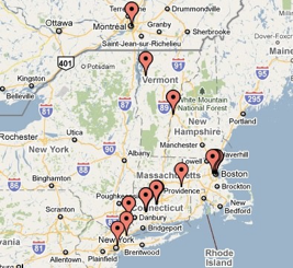
The map shows just how far we had come. The pins trace our route up from the New York area through New England, past places such as Hartford, Providence and Boston, then onwards towards Vermont and the Canadian border. The journey carried us from the busy streets of New York, through the towns and cities of the north-east, and towards southern Quebec, with Montreal marked close to the top of the map.
It looks like a fairly neat route on paper. Travelling it by bus, with traffic on the interstate and the scenery sliding past the Greyhound windows, made it feel much longer. Still, the bus gave us time to watch the landscape change and to get used to the strange excitement of moving on to somewhere new.
New York had been our first taste of the trip. Boston had given us its harbour, historic streets and a chance to stretch our legs. Now the red pins were pointing north, towards the border and the next country on our map.
Canada, here we come!